


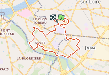
saint Sébastien sur Loire dép : Le Douet

Fauvette 44
User

Length
9.8 km

Max alt
28 m

Uphill gradient
61 m
Km-Effort
10.7 km

Min alt
3 m

Downhill gradient
61 m
Boucle
Yes
Creation date :
2025-01-17 13:11:33.943
Updated on :
2025-01-18 11:04:40.217
2h25
Difficulty : Medium

FREE GPS app for hiking
 SityTrail
IGN / Geographical institutes
SityTrail Plus
The world is yours!
About
Trail Walking of 9.8 km to be discovered at Pays de la Loire, Loire-Atlantique, Saint-Sébastien-sur-Loire. This trail is proposed by Fauvette 44.
Positioning
Country:
France
Region :
Pays de la Loire
Department/Province :
Loire-Atlantique
Municipality :
Saint-Sébastien-sur-Loire
Location:
Unknown
Start:(Dec)
Start:(UTM)
612246 ; 5227727 (30T) N.
Comments