


De Frontignan au Roc d'Anduze

ARVIEU
User
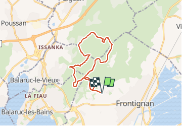

Length
14.6 km

Max alt
229 m

Uphill gradient
410 m
Km-Effort
20 km

Min alt
45 m

Downhill gradient
410 m
Boucle
Yes
Creation date :
2025-01-18 06:34:29.4
Updated on :
2025-01-18 06:35:30.333
5h00
Difficulty : Medium

FREE GPS app for hiking
 SityTrail
IGN / Geographical institutes
SityTrail Plus
The world is yours!
About
Trail Walking of 14.6 km to be discovered at Occitania, Hérault, Frontignan. This trail is proposed by ARVIEU.
Points of interest


Positioning
Country:
France
Region :
Occitania
Department/Province :
Hérault
Municipality :
Frontignan
Location:
Unknown
Start:(Dec)
Start:(UTM)
559120 ; 4811454 (31T) N.
Comments