


2 Mas de Londres par la Jasse du 18-01-2025

VANDERPUTTENMi
User GUIDE
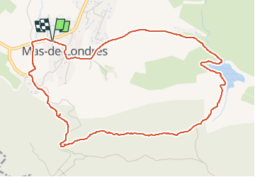

Length
6.2 km

Max alt
276 m

Uphill gradient
104 m
Km-Effort
7.6 km

Min alt
196 m

Downhill gradient
107 m
Boucle
Yes
Creation date :
2025-01-18 07:58:13.677
Updated on :
2025-01-18 10:25:09.228
1h28
Difficulty : Medium

FREE GPS app for hiking
 SityTrail
IGN / Geographical institutes
SityTrail Plus
The world is yours!
About
Trail Walking of 6.2 km to be discovered at Occitania, Hérault, Mas-de-Londres. This trail is proposed by VANDERPUTTENMi.
Description
Boucle tranquille sans dénivelés importants
Photos


Positioning
Country:
France
Region :
Occitania
Department/Province :
Hérault
Municipality :
Mas-de-Londres
Location:
Unknown
Start:(Dec)
Start:(UTM)
560747 ; 4848257 (31T) N.
Comments