


trail journans / smdm /tossiat

bubufred
User
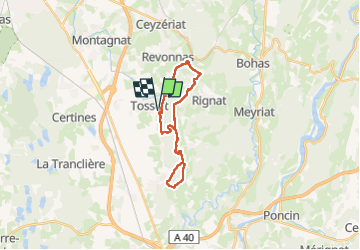

Length
20 km

Max alt
503 m

Uphill gradient
619 m
Km-Effort
29 km

Min alt
275 m

Downhill gradient
619 m
Boucle
Yes
Creation date :
2025-01-19 07:40:55.208
Updated on :
2025-01-19 10:44:59.9
2h33
Difficulty : Very easy

FREE GPS app for hiking
 SityTrail
IGN / Geographical institutes
SityTrail Plus
The world is yours!
About
Trail Trail of 20 km to be discovered at Auvergne-Rhône-Alpes, Ain, Tossiat. This trail is proposed by bubufred.
Positioning
Country:
France
Region :
Auvergne-Rhône-Alpes
Department/Province :
Ain
Municipality :
Tossiat
Location:
Unknown
Start:(Dec)
Start:(UTM)
679422 ; 5111763 (31T) N.
Comments