


TRK000

Rando MLC
User

Length
19 km

Max alt
193 m

Uphill gradient
202 m
Km-Effort
22 km

Min alt
95 m

Downhill gradient
201 m
Boucle
Yes
Creation date :
2025-01-19 14:33:28.906
Updated on :
2025-01-19 14:39:43.047
4h56
Difficulty : Difficult

FREE GPS app for hiking
 SityTrail
IGN / Geographical institutes
SityTrail Plus
The world is yours!
About
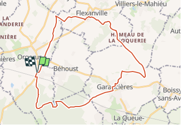
Trail Walking of 19 km to be discovered at Ile-de-France, Yvelines, Orgerus. This trail is proposed by Rando MLC.
Positioning
Country:
France
Region :
Ile-de-France
Department/Province :
Yvelines
Municipality :
Orgerus
Location:
Unknown
Start:(Dec)
Start:(UTM)
404756 ; 5409228 (31U) N.
Comments