


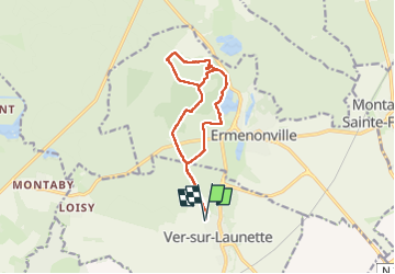
Ver sur Launette avec dénivelé raccourci
© OpenStreetMap contributors


2h15
Difficulty : Very easy


Length
12.9 km
Max alt
127 m
Uphill gradient
160 m
Km-Effort
15 km
Min alt
84 m
Downhill gradient
161 m
Boucle
Yes
Creation date :
2025-01-19 08:52:52.008
Updated on :
2025-01-19 17:26:03.711
2h15
Difficulty : Very easy
FREE GPS app for hiking
 SityTrail
IGN / Geographical institutes
SityTrail Plus
The world is yours!
About
Trail Nordic walking of 12.9 km to be discovered at Hauts-de-France, Oise, Ver-sur-Launette. This trail is proposed by damerenvielle@gmail.com.
Description
Départ Ver sur Launette, vers l'aire de Pique nique du Boisdhyver, rejoindre la "route d'Ermenoville" puis le sentier le long de la mer de sable et retour par les étangs des Crapauds et du Désert, puis Ver Sur Launette
Positioning
Country:
France
Region :
Hauts-de-France
Department/Province :
Oise
Municipality :
Ver-sur-Launette
Location:
Unknown
Start:(Dec)
Start:(UTM)
476687 ; 5439554 (31U) N.
Comments