


St Marc Jaumegarde

MAUVAGE Patrick
User
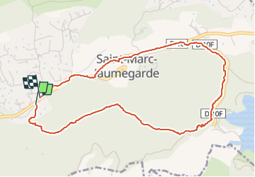

Length
5.3 km

Max alt
401 m

Uphill gradient
80 m
Km-Effort
6.4 km

Min alt
351 m

Downhill gradient
80 m
Boucle
Yes
Creation date :
2025-01-19 14:49:20.0
Updated on :
2025-01-21 14:23:32.01
1h24
Difficulty : Medium

FREE GPS app for hiking
 SityTrail
IGN / Geographical institutes
SityTrail Plus
The world is yours!
About
Trail Walking of 5.3 km to be discovered at Provence-Alpes-Côte d'Azur, Bouches-du-Rhône, Saint-Marc-Jaumegarde. This trail is proposed by MAUVAGE Patrick.
Positioning
Country:
France
Region :
Provence-Alpes-Côte d'Azur
Department/Province :
Bouches-du-Rhône
Municipality :
Saint-Marc-Jaumegarde
Location:
Unknown
Start:(Dec)
Start:(UTM)
702911 ; 4824276 (31T) N.
Comments