


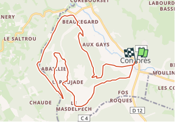
Concorès par Mas del Pech, La Poujade (Lot)

houbart
User

Length
13 km

Max alt
324 m

Uphill gradient
356 m
Km-Effort
17.8 km

Min alt
177 m

Downhill gradient
356 m
Boucle
Yes
Creation date :
2025-01-19 19:03:56.938
Updated on :
2025-01-19 19:04:23.686
4h02
Difficulty : Difficult

FREE GPS app for hiking
 SityTrail
IGN / Geographical institutes
SityTrail Plus
The world is yours!
About
Trail Walking of 13 km to be discovered at Occitania, Lot, Concorès. This trail is proposed by houbart.
Positioning
Country:
France
Region :
Occitania
Department/Province :
Lot
Municipality :
Concorès
Location:
Unknown
Start:(Dec)
Start:(UTM)
372694 ; 4946040 (31T) N.
Comments