


Assas Puech Montaud

ARVIEU
User
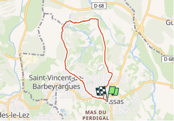

Length
6.8 km

Max alt
161 m

Uphill gradient
129 m
Km-Effort
8.5 km

Min alt
85 m

Downhill gradient
130 m
Boucle
Yes
Creation date :
2025-01-20 06:40:48.378
Updated on :
2025-01-20 06:43:10.91
3h00
Difficulty : Easy

FREE GPS app for hiking
 SityTrail
IGN / Geographical institutes
SityTrail Plus
The world is yours!
About
Trail Walking of 6.8 km to be discovered at Occitania, Hérault, Assas. This trail is proposed by ARVIEU.
Photos

Positioning
Country:
France
Region :
Occitania
Department/Province :
Hérault
Municipality :
Assas
Location:
Unknown
Start:(Dec)
Start:(UTM)
572334 ; 4839084 (31T) N.
Comments