maure viel Rocher des monges Mont st MARTIN - club le 26 JANVIER

clintest
User
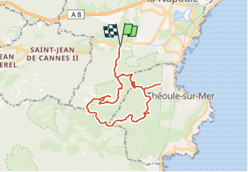

Length
16.3 km

Max alt
364 m

Uphill gradient
534 m
Km-Effort
23 km

Min alt
16 m

Downhill gradient
534 m
Boucle
Yes
Creation date :
2025-01-20 11:10:38.287
Updated on :
2025-01-20 11:11:45.311
5h19
Difficulty : Medium

FREE GPS app for hiking
 SityTrail
IGN / Geographical institutes
SityTrail Plus
The world is yours!
About
Trail On foot of 16.3 km to be discovered at Provence-Alpes-Côte d'Azur, Maritime Alps, Mandelieu-la-Napoule. This trail is proposed by clintest.
Description
rando club du 26 JANVIER
Positioning
Country:
France
Region :
Provence-Alpes-Côte d'Azur
Department/Province :
Maritime Alps
Municipality :
Mandelieu-la-Napoule
Location:
Unknown
Start:(Dec)
Start:(UTM)
331105 ; 4821136 (32T) N.
Comments