


brulet saint Irene

cbr69110
User

Length
1.4 km

Max alt
314 m

Uphill gradient
10 m
Km-Effort
1.6 km

Min alt
285 m

Downhill gradient
27 m
Boucle
No
Creation date :
2025-01-20 13:17:11.348
Updated on :
2025-01-20 14:04:27.18
46m
Difficulty : Easy

FREE GPS app for hiking
 SityTrail
IGN / Geographical institutes
SityTrail Plus
The world is yours!
About
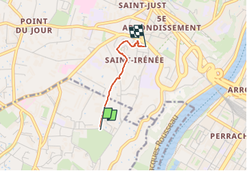
Trail Walking of 1.4 km to be discovered at Auvergne-Rhône-Alpes, Métropole de Lyon, Sainte-Foy-lès-Lyon. This trail is proposed by cbr69110.
Description
Aqueduc
Positioning
Country:
France
Region :
Auvergne-Rhône-Alpes
Department/Province :
Métropole de Lyon
Municipality :
Sainte-Foy-lès-Lyon
Location:
Unknown
Start:(Dec)
Start:(UTM)
640520 ; 5067548 (31T) N.
Comments