


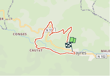
Mayres Peyralade

Rudy07
User

Length
7.1 km

Max alt
833 m

Uphill gradient
260 m
Km-Effort
10.7 km

Min alt
575 m

Downhill gradient
312 m
Boucle
No
Creation date :
2025-01-15 12:47:57.982
Updated on :
2025-01-20 16:19:26.299
122h57
Difficulty : Medium

FREE GPS app for hiking
 SityTrail
IGN / Geographical institutes
SityTrail Plus
The world is yours!
About
Trail Walking of 7.1 km to be discovered at Auvergne-Rhône-Alpes, Ardèche, Mayres. This trail is proposed by Rudy07.
Positioning
Country:
France
Region :
Auvergne-Rhône-Alpes
Department/Province :
Ardèche
Municipality :
Mayres
Location:
Unknown
Start:(Dec)
Start:(UTM)
587864 ; 4946707 (31T) N.
Comments