


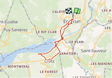
embrun

RoMo
User

Length
13.8 km

Max alt
874 m

Uphill gradient
165 m
Km-Effort
16 km

Min alt
774 m

Downhill gradient
164 m
Boucle
Yes
Creation date :
2025-01-20 10:33:27.708
Updated on :
2025-01-20 16:57:01.464
4h18
Difficulty : Medium

FREE GPS app for hiking
 SityTrail
IGN / Geographical institutes
SityTrail Plus
The world is yours!
About
Trail Walking of 13.8 km to be discovered at Provence-Alpes-Côte d'Azur, Hautes-Alpes, Embrun. This trail is proposed by RoMo.
Description
boucle jusqu'au lac
Photos


Positioning
Country:
France
Region :
Provence-Alpes-Côte d'Azur
Department/Province :
Hautes-Alpes
Municipality :
Embrun
Location:
Unknown
Start:(Dec)
Start:(UTM)
301236 ; 4937879 (32T) N.
Comments