


Randonnée 21/01/2025

cheepewa
User
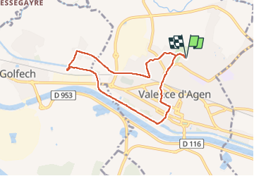

Length
7.6 km

Max alt
72 m

Uphill gradient
49 m
Km-Effort
8.2 km

Min alt
56 m

Downhill gradient
50 m
Boucle
Yes
Creation date :
2025-01-21 07:56:27.0
Updated on :
2025-01-21 09:57:43.92
1h58
Difficulty : Medium

FREE GPS app for hiking
 SityTrail
IGN / Geographical institutes
SityTrail Plus
The world is yours!
About
Trail Walking of 7.6 km to be discovered at Occitania, Tarn-et-Garonne, Valence. This trail is proposed by cheepewa.
Description
Sympa avec un petit brouillard
Positioning
Country:
France
Region :
Occitania
Department/Province :
Tarn-et-Garonne
Municipality :
Valence
Location:
Unknown
Start:(Dec)
Start:(UTM)
331419 ; 4887063 (31T) N.
Comments