


training trail

tosan
User
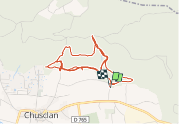

Length
7.1 km

Max alt
162 m

Uphill gradient
280 m
Km-Effort
10.8 km

Min alt
66 m

Downhill gradient
271 m
Boucle
Yes
Creation date :
2025-01-21 11:08:49.54
Updated on :
2025-01-21 12:06:57.238
57m
Difficulty : Medium

FREE GPS app for hiking
 SityTrail
IGN / Geographical institutes
SityTrail Plus
The world is yours!
About
Trail Trail of 7.1 km to be discovered at Occitania, Gard, Chusclan. This trail is proposed by tosan.
Positioning
Country:
France
Region :
Occitania
Department/Province :
Gard
Municipality :
Chusclan
Location:
Unknown
Start:(Dec)
Start:(UTM)
635575 ; 4890219 (31T) N.
Comments