


2024-01-21 grands avaux

Lucquiaud
User
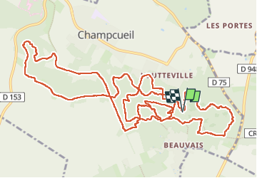

Length
17.4 km

Max alt
152 m

Uphill gradient
329 m
Km-Effort
22 km

Min alt
86 m

Downhill gradient
324 m
Boucle
Yes
Creation date :
2025-01-21 08:39:16.852
Updated on :
2025-01-21 15:37:18.108
4h57
Difficulty : Very difficult

FREE GPS app for hiking
 SityTrail
IGN / Geographical institutes
SityTrail Plus
The world is yours!
About
Trail Walking of 17.4 km to be discovered at Ile-de-France, Essonne, Champcueil. This trail is proposed by Lucquiaud.
Positioning
Country:
France
Region :
Ile-de-France
Department/Province :
Essonne
Municipality :
Champcueil
Location:
Unknown
Start:(Dec)
Start:(UTM)
460753 ; 5372304 (31U) N.
Comments