


2024-01-24

Lucquiaud
User

Length
13.5 km

Max alt
154 m

Uphill gradient
209 m
Km-Effort
16.3 km

Min alt
69 m

Downhill gradient
211 m
Boucle
Yes
Creation date :
2025-01-23 08:41:25.766
Updated on :
2025-01-23 12:51:35.576
4h09
Difficulty : Medium

FREE GPS app for hiking
 SityTrail
IGN / Geographical institutes
SityTrail Plus
The world is yours!
About
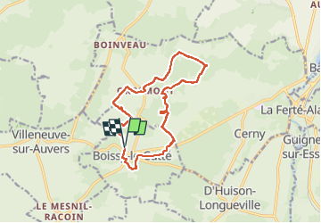
Trail Walking of 13.5 km to be discovered at Ile-de-France, Essonne, Boissy-le-Cutté. This trail is proposed by Lucquiaud.
Positioning
Country:
France
Region :
Ile-de-France
Department/Province :
Essonne
Municipality :
Boissy-le-Cutté
Location:
Unknown
Start:(Dec)
Start:(UTM)
446902 ; 5369102 (31U) N.
Comments