


course dorientation mas de daumet

xav34830
User
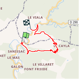

Length
6.1 km

Max alt
623 m

Uphill gradient
375 m
Km-Effort
11 km

Min alt
268 m

Downhill gradient
343 m
Boucle
No
Creation date :
2015-06-12 00:00:00.0
Updated on :
2015-06-12 00:00:00.0
--
Difficulty : Easy

FREE GPS app for hiking
 SityTrail
IGN / Geographical institutes
SityTrail Plus
The world is yours!
About
Trail Walking of 6.1 km to be discovered at Occitania, Gard, Sumène. This trail is proposed by xav34830.
Positioning
Country:
France
Region :
Occitania
Department/Province :
Gard
Municipality :
Sumène
Location:
Unknown
Start:(Dec)
Start:(UTM)
557353 ; 4873438 (31T) N.
Comments