


Minett Trail: Esch-sur-Alzette Gare - Tétange Gare

verpoorten
User
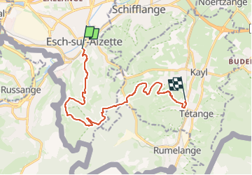

Length
11.9 km

Max alt
430 m

Uphill gradient
349 m
Km-Effort
16.6 km

Min alt
286 m

Downhill gradient
339 m
Boucle
No
Creation date :
2025-01-25 13:45:35.882
Updated on :
2025-02-19 16:11:22.116
3h45
Difficulty : Difficult

FREE GPS app for hiking
 SityTrail
IGN / Geographical institutes
SityTrail Plus
The world is yours!
About
Trail Walking of 11.9 km to be discovered at Unknown, Canton Esch-sur-Alzette, Kayl. This trail is proposed by verpoorten.
Positioning
Country:
Luxembourg
Region :
Unknown
Department/Province :
Canton Esch-sur-Alzette
Municipality :
Kayl
Location:
Unknown
Start:(Dec)
Start:(UTM)
285238 ; 5484735 (32U) N.
Comments