


SityTrail - GERBEROY WAMBEZ BELLEFONTAINE SONGEONS boucle 21 km

annickmillepattes
User
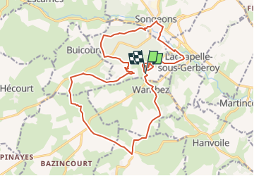

Length
21 km

Max alt
215 m

Uphill gradient
360 m
Km-Effort
25 km

Min alt
107 m

Downhill gradient
358 m
Boucle
Yes
Creation date :
2025-01-25 15:24:51.079
Updated on :
2025-01-25 15:25:53.952
5h46
Difficulty : Medium

FREE GPS app for hiking
 SityTrail
IGN / Geographical institutes
SityTrail Plus
The world is yours!
About
Trail On foot of 21 km to be discovered at Hauts-de-France, Oise, Gerberoy. This trail is proposed by annickmillepattes.
Points of interest


Positioning
Country:
France
Region :
Hauts-de-France
Department/Province :
Oise
Municipality :
Gerberoy
Location:
Unknown
Start:(Dec)
Start:(UTM)
416694 ; 5487245 (31U) N.
Comments