


Vers col bastanet en hiver

martin.mondeville
User
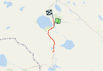

Length
1.9 km

Max alt
2363 m

Uphill gradient
111 m
Km-Effort
3.5 km

Min alt
2218 m

Downhill gradient
134 m
Boucle
No
Creation date :
2025-01-25 09:50:40.0
Updated on :
2025-01-25 17:28:16.166

FREE GPS app for hiking
 SityTrail
IGN / Geographical institutes
SityTrail Plus
The world is yours!
About
Trail of 1.9 km to be discovered at Occitania, Hautespyrenees, Bagnères-de-Bigorre. This trail is proposed by martin.mondeville.
Positioning
Country:
France
Region :
Occitania
Department/Province :
Hautespyrenees
Municipality :
Bagnères-de-Bigorre
Location:
Unknown
Start:(Dec)
Start:(UTM)
271788 ; 4751251 (31T) N.
Comments