


St Vincent ladoix

iznogud
User
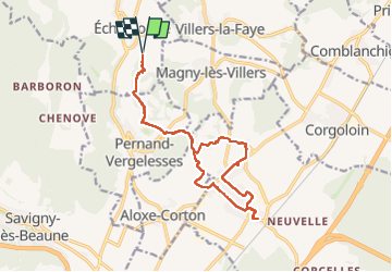

Length
16 km

Max alt
428 m

Uphill gradient
351 m
Km-Effort
21 km

Min alt
206 m

Downhill gradient
352 m
Boucle
Yes
Creation date :
2025-01-25 10:22:37.0
Updated on :
2025-01-25 17:47:55.935

FREE GPS app for hiking
 SityTrail
IGN / Geographical institutes
SityTrail Plus
The world is yours!
About
Trail of 16 km to be discovered at Bourgogne-Franche-Comté, Côte-d'Or, Échevronne. This trail is proposed by iznogud.
Positioning
Country:
France
Region :
Bourgogne-Franche-Comté
Department/Province :
Côte-d'Or
Municipality :
Échevronne
Location:
Unknown
Start:(Dec)
Start:(UTM)
640654 ; 5217978 (31T) N.
Comments