


21012025

Patrick Cabot
User
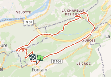

Length
10.9 km

Max alt
491 m

Uphill gradient
253 m
Km-Effort
14.3 km

Min alt
307 m

Downhill gradient
246 m
Boucle
Yes
Creation date :
2025-01-26 10:00:36.171
Updated on :
2025-01-26 12:35:34.904
2h34
Difficulty : Difficult

FREE GPS app for hiking
 SityTrail
IGN / Geographical institutes
SityTrail Plus
The world is yours!
About
Trail Walking of 10.9 km to be discovered at Bourgogne-Franche-Comté, Doubs, Fontain. This trail is proposed by Patrick Cabot.
Positioning
Country:
France
Region :
Bourgogne-Franche-Comté
Department/Province :
Doubs
Municipality :
Fontain
Location:
Fontain
Start:(Dec)
Start:(UTM)
274603 ; 5231675 (32T) N.
Comments