


T-Autour de Mondeville

RANDOH
User
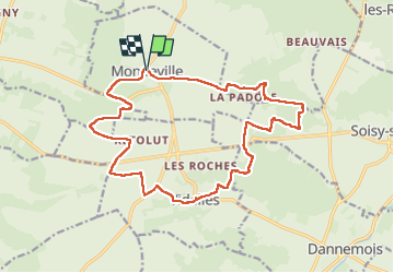

Length
17.9 km

Max alt
149 m

Uphill gradient
268 m
Km-Effort
21 km

Min alt
81 m

Downhill gradient
270 m
Boucle
Yes
Creation date :
2025-01-26 08:30:46.429
Updated on :
2025-01-31 12:16:03.401
6h19
Difficulty : Medium

FREE GPS app for hiking
 SityTrail
IGN / Geographical institutes
SityTrail Plus
The world is yours!
About
Trail Walking of 17.9 km to be discovered at Ile-de-France, Essonne, Mondeville. This trail is proposed by RANDOH.
Positioning
Country:
France
Region :
Ile-de-France
Department/Province :
Essonne
Municipality :
Mondeville
Location:
Unknown
Start:(Dec)
Start:(UTM)
456813 ; 5371045 (31U) N.
Comments