


Les Sommets du Mont Lozere 320+

claude nier
User
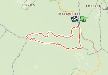

Length
14.4 km

Max alt
1699 m

Uphill gradient
320 m
Km-Effort
18.6 km

Min alt
1473 m

Downhill gradient
322 m
Boucle
Yes
Creation date :
2025-01-26 18:05:05.578
Updated on :
2025-01-26 18:06:12.408
4h14
Difficulty : Easy

FREE GPS app for hiking
 SityTrail
IGN / Geographical institutes
SityTrail Plus
The world is yours!
About
Trail On foot of 14.4 km to be discovered at Occitania, Lozère, Cubières. This trail is proposed by claude nier.
Description
depart station ski du Bleymard
Positioning
Country:
France
Region :
Occitania
Department/Province :
Lozère
Municipality :
Cubières
Location:
Unknown
Start:(Dec)
Start:(UTM)
559548 ; 4921599 (31T) N.
Comments