


Boucle de Pelens

jlrayon
User
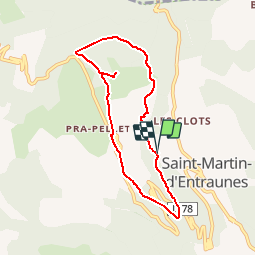

Length
7.2 km

Max alt
1639 m

Uphill gradient
543 m
Km-Effort
14.5 km

Min alt
1135 m

Downhill gradient
553 m
Boucle
Yes
Creation date :
2015-06-13 00:00:00.0
Updated on :
2015-06-13 00:00:00.0
2h57
Difficulty : Unknown

FREE GPS app for hiking
 SityTrail
IGN / Geographical institutes
SityTrail Plus
The world is yours!
About
Trail Walking of 7.2 km to be discovered at Provence-Alpes-Côte d'Azur, Maritime Alps, Saint-Martin-d'Entraunes. This trail is proposed by jlrayon.
Positioning
Country:
France
Region :
Provence-Alpes-Côte d'Azur
Department/Province :
Maritime Alps
Municipality :
Saint-Martin-d'Entraunes
Location:
Unknown
Start:(Dec)
Start:(UTM)
320348 ; 4890470 (32T) N.
Comments
très beau petit circuit