


Crêtes du Canier-31/01/2025-1/2J-G1

lmc
User
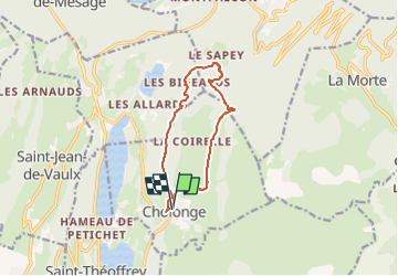

Length
10.3 km

Max alt
1326 m

Uphill gradient
519 m
Km-Effort
17.3 km

Min alt
1029 m

Downhill gradient
521 m
Boucle
Yes
Creation date :
2025-01-27 16:04:21.26
Updated on :
2025-01-27 16:05:52.881
3h55
Difficulty : Easy

FREE GPS app for hiking
 SityTrail
IGN / Geographical institutes
SityTrail Plus
The world is yours!
About
Trail Walking of 10.3 km to be discovered at Auvergne-Rhône-Alpes, Isère, Cholonge. This trail is proposed by lmc.
Positioning
Country:
France
Region :
Auvergne-Rhône-Alpes
Department/Province :
Isère
Municipality :
Cholonge
Location:
Unknown
Start:(Dec)
Start:(UTM)
720368 ; 4987076 (31T) N.
Comments