


2025-01-28 Midi
© OpenStreetMap contributors


16m
Difficulty : Easy


Length
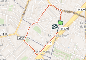
1.7 km
Max alt
47 m
Uphill gradient
11 m
Km-Effort
1.8 km
Min alt
37 m
Downhill gradient
9 m
Boucle
Yes
Creation date :
2025-01-28 11:49:18.0
Updated on :
2025-01-28 12:06:16.575
16m
Difficulty : Easy
FREE GPS app for hiking
 SityTrail
IGN / Geographical institutes
SityTrail Plus
The world is yours!
About
Trail Walking of 1.7 km to be discovered at Hauts-de-France, Nord, Marcq-en-Barœul. This trail is proposed by 001176.05285939d7c848918be5cbf93d931c37.0558.
Positioning
Country:
France
Region :
Hauts-de-France
Department/Province :
Nord
Municipality :
Marcq-en-Barœul
Location:
Unknown
Start:(Dec)
Start:(UTM)
506000 ; 5611467 (31U) N.
Comments