


Chatel 1

vador67
User
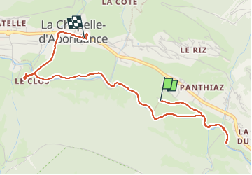

Length
4.6 km

Max alt
1029 m

Uphill gradient
64 m
Km-Effort
5.4 km

Min alt
993 m

Downhill gradient
48 m
Boucle
No
Creation date :
2025-01-29 09:20:44.0
Updated on :
2025-01-29 11:09:07.935
1h47
Difficulty : Easy

FREE GPS app for hiking
 SityTrail
IGN / Geographical institutes
SityTrail Plus
The world is yours!
About
Trail Walking of 4.6 km to be discovered at Auvergne-Rhône-Alpes, Upper Savoy, La Chapelle-d'Abondance. This trail is proposed by vador67.
Description
Facile
Positioning
Country:
France
Region :
Auvergne-Rhône-Alpes
Department/Province :
Upper Savoy
Municipality :
La Chapelle-d'Abondance
Location:
Unknown
Start:(Dec)
Start:(UTM)
330472 ; 5128611 (32T) N.
Comments