


Rouffiac/la Tuffière/Montialoux

tyntyn
User
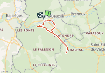

Length
10.8 km

Max alt
876 m

Uphill gradient
276 m
Km-Effort
14.5 km

Min alt
708 m

Downhill gradient
293 m
Boucle
Yes
Creation date :
2025-01-29 12:59:37.64
Updated on :
2025-02-03 10:03:11.858
2h39
Difficulty : Easy

FREE GPS app for hiking
 SityTrail
IGN / Geographical institutes
SityTrail Plus
The world is yours!
About
Trail Walking of 10.8 km to be discovered at Occitania, Lozère, Saint-Bauzile. This trail is proposed by tyntyn.
Photos


Positioning
Country:
France
Region :
Occitania
Department/Province :
Lozère
Municipality :
Saint-Bauzile
Location:
Unknown
Start:(Dec)
Start:(UTM)
539172 ; 4925126 (31T) N.
Comments