


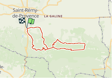
Saint Rémy par les crêtes

Roger Philippe Wallez
User GUIDE

Length
16.5 km

Max alt
391 m

Uphill gradient
671 m
Km-Effort
25 km

Min alt
102 m

Downhill gradient
672 m
Boucle
Yes
Creation date :
2025-01-29 09:10:36.0
Updated on :
2025-01-29 16:13:07.527
6h12
Difficulty : Very difficult

FREE GPS app for hiking
 SityTrail
IGN / Geographical institutes
SityTrail Plus
The world is yours!
About
Trail Walking of 16.5 km to be discovered at Provence-Alpes-Côte d'Azur, Bouches-du-Rhône, Saint-Rémy-de-Provence. This trail is proposed by Roger Philippe Wallez.
Photos


Positioning
Country:
France
Region :
Provence-Alpes-Côte d'Azur
Department/Province :
Bouches-du-Rhône
Municipality :
Saint-Rémy-de-Provence
Location:
Unknown
Start:(Dec)
Start:(UTM)
647547 ; 4848668 (31T) N.
Comments