


Projet Rando CLAS du 06/02/2025 par PBo

boubou68
User
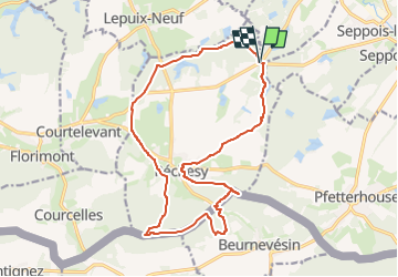

Length
17.4 km

Max alt
563 m

Uphill gradient
370 m
Km-Effort
22 km

Min alt
402 m

Downhill gradient
367 m
Boucle
Yes
Creation date :
2025-01-31 17:23:26.24
Updated on :
2025-01-31 17:23:30.048
5h03
Difficulty : Very difficult

FREE GPS app for hiking
 SityTrail
IGN / Geographical institutes
SityTrail Plus
The world is yours!
About
Trail Walking of 17.4 km to be discovered at Bourgogne-Franche-Comté, Territoire-de-Belfort, Réchésy. This trail is proposed by boubou68.
Positioning
Country:
France
Region :
Bourgogne-Franche-Comté
Department/Province :
Territoire-de-Belfort
Municipality :
Réchésy
Location:
Unknown
Start:(Dec)
Start:(UTM)
359750 ; 5265800 (32T) N.
Comments