


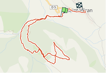
Crête de Curlet (Saint-Véran 05) Raquettes

Clo0413
User

Length
8.4 km

Max alt
2365 m

Uphill gradient
681 m
Km-Effort
17.5 km

Min alt
1849 m

Downhill gradient
679 m
Boucle
Yes
Creation date :
2025-02-01 08:38:22.415
Updated on :
2025-02-03 07:17:11.802
3h58
Difficulty : Difficult

FREE GPS app for hiking
 SityTrail
IGN / Geographical institutes
SityTrail Plus
The world is yours!
About
Trail Walking of 8.4 km to be discovered at Provence-Alpes-Côte d'Azur, Hautes-Alpes, Saint-Véran. This trail is proposed by Clo0413.
Positioning
Country:
France
Region :
Provence-Alpes-Côte d'Azur
Department/Province :
Hautes-Alpes
Municipality :
Saint-Véran
Location:
Unknown
Start:(Dec)
Start:(UTM)
331233 ; 4951732 (32T) N.
Comments