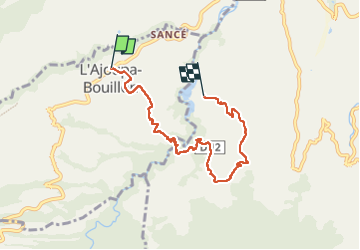
L'Ajoupa-Bouillon - Le Lorrain via Saut Babin

Lamartiniere
User GUIDE


2h53
Difficulty : Medium

FREE GPS app for hiking
 SityTrail
IGN / Geographical institutes
SityTrail Plus
The world is yours!
About
Trail Walking of 9.2 km to be discovered at Martinique, Unknown, L'Ajoupa-Bouillon. This trail is proposed by Lamartiniere.
Description
Randonnée de 9,2 km avec départ à L' Ajoupa-Bouillon et arrivée à l' Océanic-Club de Morne Capot en contournant Morne Dégras, Le Lorrain. Cette randonnée qui se pratique par BEAU TEMPS nécessite obligatoire 5 autorisations de passage sur des parcelles privées. Traversée rivière La Capot sur Pont de singe et à gué rivière La Pirogue. En cas de crue rivière La Pirogue, contourner sur les hauteurs par l'exploitation agricole Larougery pour sortir à Morne Capot.
Positioning
Comments