


Merbes le château 02-02-2025

CapTom
User
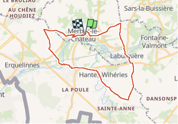

Length
15.6 km

Max alt
172 m

Uphill gradient
177 m
Km-Effort
18 km

Min alt
118 m

Downhill gradient
177 m
Boucle
Yes
Creation date :
2025-02-02 09:24:45.0
Updated on :
2025-02-02 12:50:39.479
3h09
Difficulty : Difficult

FREE GPS app for hiking
 SityTrail
IGN / Geographical institutes
SityTrail Plus
The world is yours!
About
Trail Walking of 15.6 km to be discovered at Wallonia, Hainaut, Merbes-le-Château. This trail is proposed by CapTom.
Positioning
Country:
Belgium
Region :
Wallonia
Department/Province :
Hainaut
Municipality :
Merbes-le-Château
Location:
Unknown
Start:(Dec)
Start:(UTM)
582980 ; 5575241 (31U) N.
Comments