


la Riondaz

Mariolebeno
User
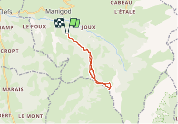

Length
10.1 km

Max alt
1748 m

Uphill gradient
591 m
Km-Effort
18 km

Min alt
1161 m

Downhill gradient
593 m
Boucle
Yes
Creation date :
2025-02-02 09:42:17.374
Updated on :
2025-02-05 17:35:03.332
2h46
Difficulty : Easy

FREE GPS app for hiking
 SityTrail
IGN / Geographical institutes
SityTrail Plus
The world is yours!
About
Trail Touring skiing of 10.1 km to be discovered at Auvergne-Rhône-Alpes, Upper Savoy, Manigod. This trail is proposed by Mariolebeno.
Positioning
Country:
France
Region :
Auvergne-Rhône-Alpes
Department/Province :
Upper Savoy
Municipality :
Manigod
Location:
Unknown
Start:(Dec)
Start:(UTM)
296313 ; 5080708 (32T) N.
Comments