


Col De la Botte en circuit

Emelle
User
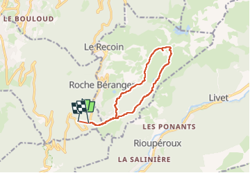

Length
11.8 km

Max alt
2248 m

Uphill gradient
709 m
Km-Effort
21 km

Min alt
1565 m

Downhill gradient
657 m
Boucle
No
Creation date :
2025-02-02 08:39:05.533
Updated on :
2025-02-02 14:45:33.307
6h03
Difficulty : Medium

FREE GPS app for hiking
 SityTrail
IGN / Geographical institutes
SityTrail Plus
The world is yours!
About
Trail Snowshoes of 11.8 km to be discovered at Auvergne-Rhône-Alpes, Isère, Vaulnaveys-le-Haut. This trail is proposed by Emelle.
Photos

Positioning
Country:
France
Region :
Auvergne-Rhône-Alpes
Department/Province :
Isère
Municipality :
Vaulnaveys-le-Haut
Location:
Unknown
Start:(Dec)
Start:(UTM)
725366 ; 4998031 (31T) N.
Comments