


J4 - AUBRAC 2025 - FORET DE LAGUIOLE - GR

jmp76700
User
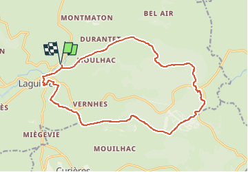

Length
19.2 km

Max alt
1326 m

Uphill gradient
450 m
Km-Effort
25 km

Min alt
986 m

Downhill gradient
450 m
Boucle
Yes
Creation date :
2025-02-02 18:01:20.783
Updated on :
2025-05-10 17:58:18.776
5h42
Difficulty : Very difficult

FREE GPS app for hiking
 SityTrail
IGN / Geographical institutes
SityTrail Plus
The world is yours!
About
Trail Walking of 19.2 km to be discovered at Occitania, Aveyron, Laguiole. This trail is proposed by jmp76700.
Positioning
Country:
France
Region :
Occitania
Department/Province :
Aveyron
Municipality :
Laguiole
Location:
Unknown
Start:(Dec)
Start:(UTM)
488880 ; 4948610 (31T) N.
Comments