


Quentinoise bis BS 8 km

bstebe
User

Length
8.1 km

Max alt
342 m

Uphill gradient
197 m
Km-Effort
10.7 km

Min alt
162 m

Downhill gradient
195 m
Boucle
Yes
Creation date :
2025-02-03 10:58:21.357
Updated on :
2025-02-03 11:04:19.211
2h25
Difficulty : Medium

FREE GPS app for hiking
 SityTrail
IGN / Geographical institutes
SityTrail Plus
The world is yours!
About
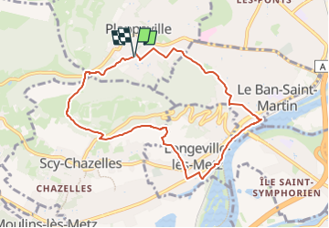
Trail Walking of 8.1 km to be discovered at Grand Est, Moselle, Plappeville. This trail is proposed by bstebe.
Description
Départ Eglise de Plappeville. Descente vers Ban Saint Martin. Voie verte. Longevile lès Metz. Croix du gibet, Scy Chazelles. Tour Fort Girardin. Col de Lessy. Arboretum. Retour Eglise de Plappeville.
Positioning
Country:
France
Region :
Grand Est
Department/Province :
Moselle
Municipality :
Plappeville
Location:
Unknown
Start:(Dec)
Start:(UTM)
290219 ; 5445608 (32U) N.
Comments