


rrd cesson 8 fevrier 2025

annierrd
User
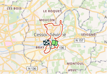

Length
12.1 km

Max alt
57 m

Uphill gradient
117 m
Km-Effort
13.6 km

Min alt
25 m

Downhill gradient
116 m
Boucle
Yes
Creation date :
2025-02-03 12:06:21.267
Updated on :
2025-02-03 14:42:08.224
2h35
Difficulty : Difficult

FREE GPS app for hiking
 SityTrail
IGN / Geographical institutes
SityTrail Plus
The world is yours!
About
Trail Walking of 12.1 km to be discovered at Brittany, Ille-et-Vilaine, Cesson-Sévigné. This trail is proposed by annierrd.
Positioning
Country:
France
Region :
Brittany
Department/Province :
Ille-et-Vilaine
Municipality :
Cesson-Sévigné
Location:
Unknown
Start:(Dec)
Start:(UTM)
603978 ; 5329271 (30U) N.
Comments