


MN-S Ger02-20×5

LouisROGER
User GUIDE
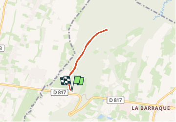

Length
4.6 km

Max alt
407 m

Uphill gradient
35 m
Km-Effort
5 km

Min alt
392 m

Downhill gradient
34 m
Boucle
Yes
Creation date :
2025-02-03 13:06:02.371
Updated on :
2025-02-03 14:44:08.843
1h37
Difficulty : Very easy

FREE GPS app for hiking
 SityTrail
IGN / Geographical institutes
SityTrail Plus
The world is yours!
About
Trail Nordic walking of 4.6 km to be discovered at Occitania, Hautespyrenees, Ibos. This trail is proposed by LouisROGER.
Positioning
Country:
France
Region :
Occitania
Department/Province :
Hautespyrenees
Municipality :
Ibos
Location:
Unknown
Start:(Dec)
Start:(UTM)
741571 ; 4792380 (30T) N.
Comments