


Le Theil 18.00-20643140

togolo28
User
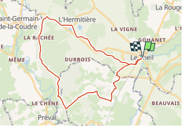

Length
18 km

Max alt
189 m

Uphill gradient
242 m
Km-Effort
21 km

Min alt
95 m

Downhill gradient
242 m
Boucle
Yes
Creation date :
2025-02-04 14:05:01.819
Updated on :
2025-02-04 14:05:30.306
--
Difficulty : Medium

FREE GPS app for hiking
 SityTrail
IGN / Geographical institutes
SityTrail Plus
The world is yours!
About
Trail Walking of 18 km to be discovered at Normandy, Orne, Val-au-Perche. This trail is proposed by togolo28.
Positioning
Country:
France
Region :
Normandy
Department/Province :
Orne
Municipality :
Val-au-Perche
Location:
Unknown
Start:(Dec)
Start:(UTM)
328494 ; 5348232 (31U) N.
Comments