


CERESTE .PRIEURÉ DE CARLUC N

RobinMicheline
User GUIDE
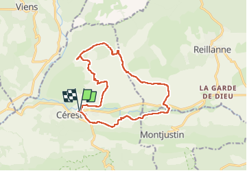

Length
15.9 km

Max alt
588 m

Uphill gradient
330 m
Km-Effort
20 km

Min alt
363 m

Downhill gradient
327 m
Boucle
Yes
Creation date :
2025-02-04 08:14:34.897
Updated on :
2025-02-04 14:35:02.898
6h05
Difficulty : Very difficult

FREE GPS app for hiking
 SityTrail
IGN / Geographical institutes
SityTrail Plus
The world is yours!
About
Trail Walking of 15.9 km to be discovered at Provence-Alpes-Côte d'Azur, Alpes-de-Haute-Provence, Céreste. This trail is proposed by RobinMicheline.
Photos


Positioning
Country:
France
Region :
Provence-Alpes-Côte d'Azur
Department/Province :
Alpes-de-Haute-Provence
Municipality :
Céreste
Location:
Unknown
Start:(Dec)
Start:(UTM)
708448 ; 4859304 (31T) N.
Comments