


clemenciere GR2

michel38
User
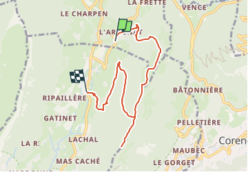

Length
7.5 km

Max alt
1043 m

Uphill gradient
398 m
Km-Effort
13.3 km

Min alt
584 m

Downhill gradient
523 m
Boucle
No
Creation date :
2025-02-04 15:41:29.426
Updated on :
2025-02-04 15:43:15.671
3h00
Difficulty : Difficult

FREE GPS app for hiking
 SityTrail
IGN / Geographical institutes
SityTrail Plus
The world is yours!
About
Trail Walking of 7.5 km to be discovered at Auvergne-Rhône-Alpes, Isère, Quaix-en-Chartreuse. This trail is proposed by michel38.
Positioning
Country:
France
Region :
Auvergne-Rhône-Alpes
Department/Province :
Isère
Municipality :
Quaix-en-Chartreuse
Location:
Unknown
Start:(Dec)
Start:(UTM)
714432 ; 5012934 (31T) N.
Comments