


Châlonvillars - le Salbert - retour par Le Rougeot

Bart2015
User
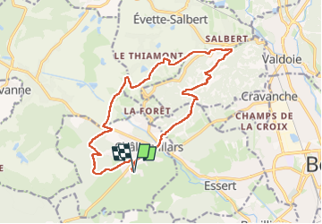

Length
15.9 km

Max alt
641 m

Uphill gradient
454 m
Km-Effort
22 km

Min alt
370 m

Downhill gradient
454 m
Boucle
Yes
Creation date :
2025-02-04 13:13:14.81
Updated on :
2025-02-05 10:03:51.429
4h59
Difficulty : Very difficult

FREE GPS app for hiking
 SityTrail
IGN / Geographical institutes
SityTrail Plus
The world is yours!
About
Trail Walking of 15.9 km to be discovered at Bourgogne-Franche-Comté, Haute-Saône, Châlonvillars. This trail is proposed by Bart2015.
Positioning
Country:
France
Region :
Bourgogne-Franche-Comté
Department/Province :
Haute-Saône
Municipality :
Châlonvillars
Location:
Unknown
Start:(Dec)
Start:(UTM)
333605 ; 5278208 (32T) N.
Comments