


Hyères Notre dame de la Consolation

Yot
User
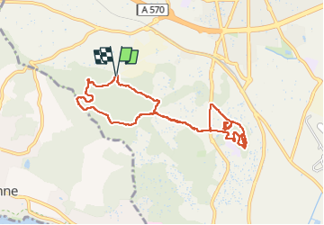

Length
10.4 km

Max alt
190 m

Uphill gradient
241 m
Km-Effort
13.7 km

Min alt
53 m

Downhill gradient
249 m
Boucle
Yes
Creation date :
2025-02-05 09:34:36.276
Updated on :
2025-02-05 14:24:36.814
3h09
Difficulty : Easy

FREE GPS app for hiking
 SityTrail
IGN / Geographical institutes
SityTrail Plus
The world is yours!
About
Trail Walking of 10.4 km to be discovered at Provence-Alpes-Côte d'Azur, Var, Hyères. This trail is proposed by Yot.
Description
Ballade avec un nouveau Guide Lyonnais
Positioning
Country:
France
Region :
Provence-Alpes-Côte d'Azur
Department/Province :
Var
Municipality :
Hyères
Location:
Unknown
Start:(Dec)
Start:(UTM)
264300 ; 4776766 (32T) N.
Comments