


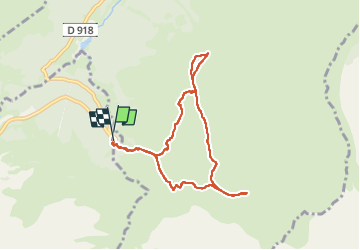
Sommet TUHOU GRAN 1911m

chrisgps
User

Length
8.4 km

Max alt
1910 m

Uphill gradient
591 m
Km-Effort
16.3 km

Min alt
1423 m

Downhill gradient
595 m
Boucle
Yes
Creation date :
2025-02-05 08:07:02.763
Updated on :
2025-02-06 19:43:23.837
3h42
Difficulty : Difficult

FREE GPS app for hiking
 SityTrail
IGN / Geographical institutes
SityTrail Plus
The world is yours!
About
Trail Walking of 8.4 km to be discovered at Occitania, Hautespyrenees, Bagnères-de-Bigorre. This trail is proposed by chrisgps.
Description
via le Pla de las Pénès-1904m avec une belle couche de neige
Photos


Positioning
Country:
France
Region :
Occitania
Department/Province :
Hautespyrenees
Municipality :
Bagnères-de-Bigorre
Location:
Unknown
Start:(Dec)
Start:(UTM)
272206 ; 4755401 (31T) N.
Comments