


Chantemerle

claudel
User
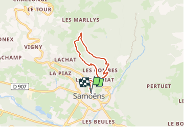

Length
5.5 km

Max alt
1137 m

Uphill gradient
415 m
Km-Effort
11 km

Min alt
708 m

Downhill gradient
422 m
Boucle
Yes
Creation date :
2025-02-05 15:58:05.814
Updated on :
2025-02-05 15:58:09.287
2h30
Difficulty : Medium

FREE GPS app for hiking
 SityTrail
IGN / Geographical institutes
SityTrail Plus
The world is yours!
About
Trail Walking of 5.5 km to be discovered at Auvergne-Rhône-Alpes, Upper Savoy, Samoëns. This trail is proposed by claudel.
Positioning
Country:
France
Region :
Auvergne-Rhône-Alpes
Department/Province :
Upper Savoy
Municipality :
Samoëns
Location:
Unknown
Start:(Dec)
Start:(UTM)
324328 ; 5105906 (32T) N.
Comments