


St Jean louverné

FOUCAULT
User
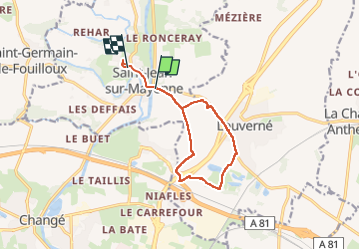

Length
10.4 km

Max alt
113 m

Uphill gradient
167 m
Km-Effort
12.5 km

Min alt
49 m

Downhill gradient
124 m
Boucle
No
Creation date :
2025-02-05 13:34:42.0
Updated on :
2025-02-05 16:52:57.903
2h49
Difficulty : Unknown

FREE GPS app for hiking
 SityTrail
IGN / Geographical institutes
SityTrail Plus
The world is yours!
About
Trail Walking of 10.4 km to be discovered at Pays de la Loire, Mayenne, Saint-Jean-sur-Mayenne. This trail is proposed by FOUCAULT.
Description
Le 5 février
Positioning
Country:
France
Region :
Pays de la Loire
Department/Province :
Mayenne
Municipality :
Saint-Jean-sur-Mayenne
Location:
Unknown
Start:(Dec)
Start:(UTM)
667569 ; 5333181 (30U) N.
Comments