


malade trace rec 2

inuit
User
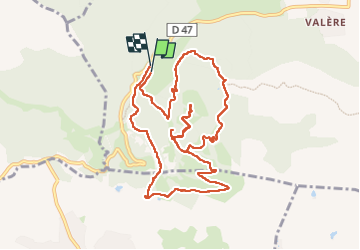

Length
12.1 km

Max alt
373 m

Uphill gradient
408 m
Km-Effort
17.6 km

Min alt
91 m

Downhill gradient
408 m
Boucle
Yes
Creation date :
2025-01-29 08:40:48.942
Updated on :
2025-02-06 11:05:34.03
5h09
Difficulty : Difficult

FREE GPS app for hiking
 SityTrail
IGN / Geographical institutes
SityTrail Plus
The world is yours!
About
Trail Walking of 12.1 km to be discovered at Provence-Alpes-Côte d'Azur, Var, Bagnols-en-Forêt. This trail is proposed by inuit.
Positioning
Country:
France
Region :
Provence-Alpes-Côte d'Azur
Department/Province :
Var
Municipality :
Bagnols-en-Forêt
Location:
Unknown
Start:(Dec)
Start:(UTM)
310492 ; 4822096 (32T) N.
Comments